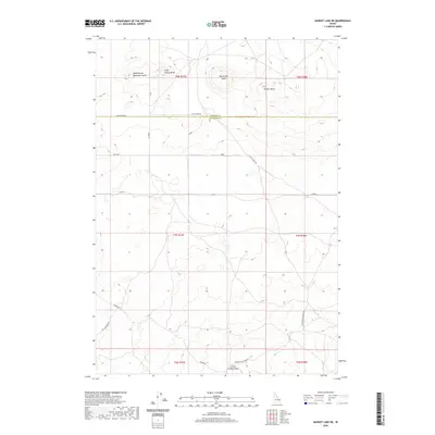
2020 Map of Market Lake NE
USGS Topo · Published 2020About this map
Sheepherder Monument Butte and Little Grassy Butte define the high points of this Jefferson County landscape, where the volcanic geology of the Snake River Plain meets the utilitarian grid of eastern Idaho's range roads. The boundary between Fremont and Jefferson Counties cuts through the northern sections, marked by the long stretch of Egin-Hamer Rd. The terrain is characterized by subtle volcanic rises and ridges, including Big Grassy Butte, Gerber Butte, and the elongated Little Grassy Ridge to the south. This is a region shaped by access and movement, where historical transit routes like Hawgood Crossing Rd and Hamer Rd intersect the desert landscape. The map provides a clear look at the township and range survey system, showing how section lines and local roads like Black Rd organize this part of Idaho's high desert plains.
Find a feature on this map
18 named features on this map. Tap any name to fly to it.
Don’t see what you’re looking for? This feature index may not catch every label — zoom into the map to look around manually.
Map Details
Editions of this 2020 Market Lake NE Map
This is the sole edition of this map. No revisions or reprints were ever made.
Other maps of this area
1951 · Menan Buttes
USGS Topo · 1:24,000

1951 · Plano
USGS Topo · 1:24,000

1955 · Dubois
USGS Topo · 1:250,000

1955 · Idaho Falls
USGS Topo · 1:250,000

1955 · Ashton
USGS Topo · 1:250,000

1955 · Driggs
USGS Topo · 1:250,000

1958 · Driggs
USGS Topo · 1:250,000

1958 · Dubois
USGS Topo · 1:250,000

1958 · Idaho Falls
USGS Topo · 1:250,000

1958 · Ashton
USGS Topo · 1:250,000