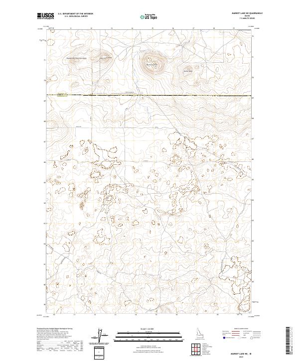
2023 Map of Market Lake NE
USGS Topo · Published 2023About this map
The high desert terrain north of Market Lake is defined by a series of prominent volcanic landforms, notably the cluster of high points including Big Grassy Butte, Little Grassy Butte, and the uniquely named Sheepherder Monument Butte. Located along the border of Fremont and Jefferson Counties, this landscape is shaped by long-established ranching and transit routes. The sparse road network, featuring Egin-Hamer Rd and Hawgood Crossing Rd, highlights the remote character of this region. The map reveals the intricate contouring of the buttes against the surrounding plains, providing a modern record of a landscape that has remained largely defined by its topography and historical boundary lines like those of Township 8 North, Range 37 East.
Find a feature on this map
17 named features on this map. Tap any name to fly to it.
Don’t see what you’re looking for? This feature index may not catch every label — zoom into the map to look around manually.
Map Details
Editions of this 2023 Market Lake NE Map
This is the sole edition of this map. No revisions or reprints were ever made.
Other maps of this area
1951 · Menan Buttes
USGS Topo · 1:24,000

1951 · Plano
USGS Topo · 1:24,000

1955 · Dubois
USGS Topo · 1:250,000

1955 · Idaho Falls
USGS Topo · 1:250,000

1955 · Ashton
USGS Topo · 1:250,000

1955 · Driggs
USGS Topo · 1:250,000

1958 · Driggs
USGS Topo · 1:250,000

1958 · Dubois
USGS Topo · 1:250,000

1958 · Idaho Falls
USGS Topo · 1:250,000

1958 · Ashton
USGS Topo · 1:250,000