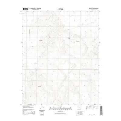
2014 Map of Markham Dam
USGS Topo · Published 2014About this map
Markham Dam and the winding course of Monument Wash anchor this high-plateau landscape in northern Arizona. The topography is defined by the significant incision of Cataract Canyon, where the seasonal waters of Cataract Cr drain toward the larger canyon systems of the region. This is a landscape engineered for water catchment in a semi-arid environment, evidenced by the numerous named stock tanks and reservoirs scattered across the rangeland. Local cattle ranching operations are supported by vital water sources such as Mahan Tank, Moore Tank, and the Little Rodgers Tanks. The area is accessed primarily via Redlands Ranch Rd and the local route CR-347, which traverse the open country between the deeply carved drainages.
Find a feature on this map
18 named features on this map. Tap any name to fly to it.
Don’t see what you’re looking for? This feature index may not catch every label — zoom into the map to look around manually.
Map Details
Editions of this 2014 Markham Dam Map
This is the sole edition of this map. No revisions or reprints were ever made.
Other maps of this area

1886 · Chino
USGS Topo · 1:250,000

1891 · Chino
USGS Topo · 1:250,000

1948 · Williams
USGS Topo · 1:250,000

1954 · Williams
USGS Topo · 1:250,000

1956 · Williams
USGS Topo · 1:250,000

1960 · Williams
USGS Topo · 1:250,000

1961 · Williams
USGS Topo · 1:250,000

1979 · Little Harpo Canyon
USGS Topo · 1:24,000
1979 · Howard Hill
USGS Topo · 1:24,000
1980 · Markham Dam
USGS Topo · 1:24,000