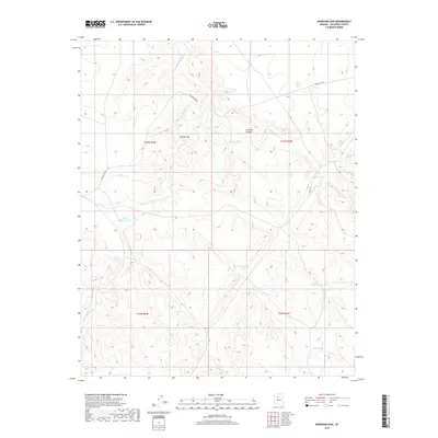
2018 Map of Markham Dam
USGS Topo · Published 2018About this map
Cataract Canyon and its associated watercourses define this high desert landscape in Coconino County, where water management is central to the land's utility. The drainage of Cataract Cr and the seasonal path of Monument Wash dictate the local topography, punctuated by numerous artificial catchment systems like Markham Dam and various livestock tanks. These features, including Little Rodgers Tanks, Mahan Tank, and Miller Tank, illustrate the historical and ongoing efforts to secure water in an arid environment. Transportation is limited to sparse corridors such as Willaha Co Rd, which threads through the township and range boundaries of t27n r2w and t27n r1w. This area reflects a specialized ranching or resource landscape where the placement of every named tank and dam represents a critical point of survival and commerce.
Find a feature on this map
16 named features on this map. Tap any name to fly to it.
Don’t see what you’re looking for? This feature index may not catch every label — zoom into the map to look around manually.
Map Details
Editions of this 2018 Markham Dam Map
This is the sole edition of this map. No revisions or reprints were ever made.
Other maps of this area

1886 · Chino
USGS Topo · 1:250,000

1891 · Chino
USGS Topo · 1:250,000

1948 · Williams
USGS Topo · 1:250,000

1954 · Williams
USGS Topo · 1:250,000

1956 · Williams
USGS Topo · 1:250,000

1960 · Williams
USGS Topo · 1:250,000

1961 · Williams
USGS Topo · 1:250,000

1979 · Little Harpo Canyon
USGS Topo · 1:24,000
1979 · Howard Hill
USGS Topo · 1:24,000
1980 · Markham Dam
USGS Topo · 1:24,000