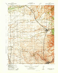
1942 Map of Markham Ravine
USGS Topo · Published 1942About this map
Johnson Rancho anchors the northern boundary of this 1940s landscape, where the agricultural and industrial foundations of western Placer County are clearly visible. The Southern Pacific (Marysville Line) and Western Pacific railroads dictate the placement of settlements like Sheridan, Ewing, and the growing hub of Lincoln. This era shows a distributed rural infrastructure with small school districts serving local families, including Fairoaks Sch, Rivervale Sch, and Central Sch.
Find a feature on this map
31 named features on this map. Tap any name to fly to it.
Don’t see what you’re looking for? This feature index may not catch every label — zoom into the map to look around manually.
Map Details
Editions of this 1942 Markham Ravine Map
This is the sole edition of this map. No revisions or reprints were ever made.
Other maps of this area

1888 · Marysville
USGS Topo · 1:125,000

1888 · Smartsville
USGS Topo · 1:125,000

1891 · Sacramento
USGS Topo · 1:125,000

1891 · Marysville
USGS Topo · 1:125,000

1891 · Smartsville
USGS Topo · 1:125,000

1892 · Sacramento
USGS Topo · 1:125,000

1892 · Smartsville
USGS Topo · 1:125,000

1893 · Sacramento
USGS Topo · 1:125,000

1894 · Smartsville
USGS Topo · 1:125,000

1894 · Marysville
USGS Topo · 1:125,000