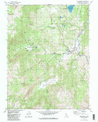
1979 Map of Markleeville
USGS Topo · Published 1980About this map
Markleeville sits at the heart of this high-elevation landscape in Alpine County, serving as a hub where the East Fork Carson River meets numerous mountain drainages. The 1970s character of the region is defined by its recreation and thermal features, notably Grover Hot Springs and the surrounding Grover Hot Springs State Park. To the north, the Indian Creek Reservoir provides a significant water body near Turtle Rock County Park. The map details a complex network of canyons and peaks, including Hawkins Peak and the deep Millberry Canyon. Evidence of land management and early infrastructure is visible through the Toiyabe National Forest boundaries, a Prospect near Poor Boy Creek, and the crossing at Hangmans Bridge. These features illustrate an economy transitioning from early resource extraction toward public land preservation and tourism.
Find a feature on this map
40 named features on this map. Tap any name to fly to it.
Don’t see what you’re looking for? This feature index may not catch every label — zoom into the map to look around manually.
Map Details
Editions of this 1979 Markleeville Map
2 editions found
Other maps of this area

1889 · Markleeville
USGS Topo · 1:125,000

1891 · Markleeville
USGS Topo · 1:125,000

1893 · Markleeville
USGS Topo · 1:125,000

1948 · Walker Lake
USGS Topo · 1:250,000
1955 · Freel Peak
USGS Topo · 1:24,000

1956 · Freel Peak
USGS Topo · 1:62,500

1956 · Topaz Lake
USGS Topo · 1:62,500

1956 · Markleeville
USGS Topo · 1:62,500

1957 · Walker Lake
USGS Topo · 1:250,000
1957 · Mt. Siegel
USGS Topo · 1:62,500