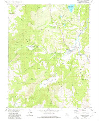
1979 Map of Markleeville
USGS Topo · Published 1980About this map
Markleeville sits as the central hub of this Alpine County landscape, positioned along the banks of the East Fork Carson River. The town is framed by an extensive network of creeks and canyons, including Musser and Jarvis Creek and Pleasant Valley Creek, which drain the high elevations of the Toiyabe National Forest. This late-1970s survey illustrates a region defined by its hydrogeology and outdoor recreation, featuring numerous springs such as Grover Hot Springs and Soda Spring.
Find a feature on this map
44 named features on this map. Tap any name to fly to it.
Don’t see what you’re looking for? This feature index may not catch every label — zoom into the map to look around manually.
Map Details
Editions of this 1979 Markleeville Map
2 editions found
Other maps of this area

1889 · Markleeville
USGS Topo · 1:125,000

1891 · Markleeville
USGS Topo · 1:125,000

1893 · Markleeville
USGS Topo · 1:125,000

1948 · Walker Lake
USGS Topo · 1:250,000
1955 · Freel Peak
USGS Topo · 1:24,000

1956 · Freel Peak
USGS Topo · 1:62,500

1956 · Topaz Lake
USGS Topo · 1:62,500

1956 · Markleeville
USGS Topo · 1:62,500

1957 · Walker Lake
USGS Topo · 1:250,000
1957 · Mt. Siegel
USGS Topo · 1:62,500