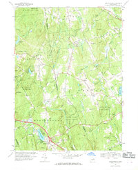
1967 Map of Marlborough
USGS Topo · Published 1969About this map
Marlborough and Gilead anchor this 1967 portrait of a Connecticut landscape defined by the transition between early rural foundations and late-century state forest management. The survey documents a territory punctuated by hilltop cemeteries and small-scale industry, such as the Sand and Gravel Pit near John Tom Hill. The terrain is deeply wooded, with the Meshomasic State Forest and Gay City State Park preserving large tracts of the upland character.
Find a feature on this map
68 named features on this map. Tap any name to fly to it.
Don’t see what you’re looking for? This feature index may not catch every label — zoom into the map to look around manually.
Map Details
Editions of this 1967 Marlborough Map
4 editions found
Other maps of this area

1892 · Hartford
USGS Topo · 1:62,500

1892 · Tolland
USGS Topo · 1:62,500

1892 · Gilead
USGS Topo · 1:62,500

1893 · Middletown
USGS Topo · 1:62,500

1906 · Farmington
USGS Topo · 1:125,000

1921 · Tolland
USGS Topo · 1:62,500

1928 · Glastonbury
USGS Topo · 1:24,000

1928 · Manchester
USGS Topo · 1:24,000

1944 · Manchester
USGS Topo · 1:31,680

1944 · Marlboro
USGS Topo · 1:31,680