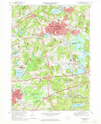
1969 Map of Marlborough
USGS Topo · Published 1971About this map
Marlborough and Westborough anchor this late-1960s landscape, illustrating a dense network of suburban growth at the intersection of the Mass Toll Road and major regional thoroughfares. The map documents significant institutional and infrastructure footprints, such as the sprawling grounds of the Westborough State Hospital and the vital water resources provided by the Sudbury Reservoir and Fort Meadow Reservoir. These massive water bodies, along with smaller features like Chauncy Lake and the Millham Reservoir, highlight the region's managed hydraulic system.
Find a feature on this map
113 named features on this map. Tap any name to fly to it.
Don’t see what you’re looking for? This feature index may not catch every label — zoom into the map to look around manually.
Map Details
Editions of this 1969 Marlborough Map
2 editions found
Other maps of this area

1886 · Blackstone
USGS Topo · 1:62,500

1886 · Framingham
USGS Topo · 1:62,500

1887 · Franklin
USGS Topo · 1:62,500

1887 · Marlboro
USGS Topo · 1:62,500

1889 · Marlboro
USGS Topo · 1:62,500

1889 · Blackstone
USGS Topo · 1:62,500

1889 · Franklin
USGS Topo · 1:62,500

1889 · Framingham
USGS Topo · 1:62,500

1893 · Franklin
USGS Topo · 1:62,500

1893 · Blackstone
USGS Topo · 1:62,500