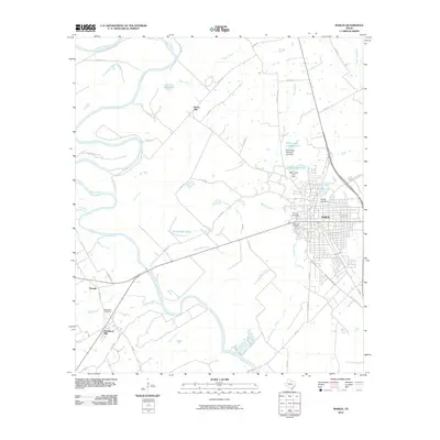
2010 Map of Marlin
USGS Topo · Published 2010About this map
The Marlin townsite sits east of a sweeping bend in the Brazos River, serving as a central hub for this region of Falls County. This landscape is defined by the river’s complex drainage patterns, where tributaries like Deer Creek, Bean Branch, and Post Oak Creek carve through the terrain. The presence of McCullough Slough and Barganier Slough highlights the low-lying, hydrologically active nature of the river valley. Local industry and land use are evident in features such as the Falls Cattle Company Lake and the Oil Mill Lake, pointing to a history tied to both ranching and processing.
Find a feature on this map
61 named features on this map. Tap any name to fly to it.
Don’t see what you’re looking for? This feature index may not catch every label — zoom into the map to look around manually.
Map Details
Editions of this 2010 Marlin Map
This is the sole edition of this map. No revisions or reprints were ever made.
Other maps of this area

1892 · Temple
USGS Topo · 1:125,000

1954 · Waco
USGS Topo · 1:250,000

1955 · Waco
USGS Topo · 1:250,000

1957 · Otto
USGS Topo · 1:24,000

1957 · McClanahan
USGS Topo · 1:24,000

1957 · Riesel
USGS Topo · 1:24,000

1957 · Chilton
USGS Topo · 1:24,000

1957 · Marlin
USGS Topo · 1:24,000
1957 · Robinson
USGS Topo · 1:24,000

1962 · Reagan
USGS Topo · 1:24,000