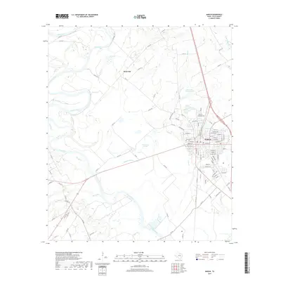
2019 Map of Marlin
USGS Topo · Published 2019About this map
The Brazos River meanders through the heart of Falls County, defining the western and southern landscape of the area surrounding Marlin. This modern survey reveals a region defined by its hydrography, where the main river channel is complemented by a complex system of sloughs and oxbows, including Barganier Slough and McCullough Slough. The city of Marlin itself is depicted with high detail, showing its street grid and industrial remnants like Oil Mill Lake. For those researching family history, the map provides precise locations for local burial grounds such as Stallworth Cem to the west and the neighboring Calvary Cem and Evergreen Cem within the town limits. The terrain is largely defined by the river bottomlands, rising toward landmarks like Rocky Hill north of town, and dotted with recreational and agricultural waters like Marlin Club Lake and Falls Cattle Company Lake.
Find a feature on this map
105 named features on this map. Tap any name to fly to it.
Don’t see what you’re looking for? This feature index may not catch every label — zoom into the map to look around manually.
Map Details
Editions of this 2019 Marlin Map
This is the sole edition of this map. No revisions or reprints were ever made.
Other maps of this area

1892 · Temple
USGS Topo · 1:125,000

1954 · Waco
USGS Topo · 1:250,000

1955 · Waco
USGS Topo · 1:250,000

1957 · Otto
USGS Topo · 1:24,000

1957 · McClanahan
USGS Topo · 1:24,000

1957 · Riesel
USGS Topo · 1:24,000

1957 · Chilton
USGS Topo · 1:24,000

1957 · Marlin
USGS Topo · 1:24,000
1957 · Robinson
USGS Topo · 1:24,000

1962 · Reagan
USGS Topo · 1:24,000