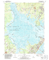
1989 Map of Marmora
USGS Topo · Published 1989About this map
Great Egg Harbor Bay and the winding Tuckahoe River dominate this coastal landscape at the junction of Atlantic and Cape May counties. The tidal marshes and wetlands are preserved within the expansive Lester G Macnamara State Wildlife Management Area, showing a terrain defined by numerous floodgates and winding tidal creeks such as Cedar Swamp Creek and Sluice Creek. This 1980s era snapshot illustrates the suburbanization of the Jersey Shore interior, with residential developments emerging near Marmora and Beesleys Point.
Find a feature on this map
76 named features on this map. Tap any name to fly to it.
Don’t see what you’re looking for? This feature index may not catch every label — zoom into the map to look around manually.
Map Details
Editions of this 1989 Marmora Map
2 editions found
Other maps of this area

1884 · Sea Isle
USGS Topo · 1:62,500

1888 · Dennisville
USGS Topo · 1:62,500

1888 · Sea Isle
USGS Topo · 1:62,500

1890 · Great Egg Harbor
USGS Topo · 1:62,500

1890 · Tuckahoe
USGS Topo · 1:62,500

1893 · Great Egg Harbor
USGS Topo · 1:62,500

1893 · Tuckahoe
USGS Topo · 1:62,500

1894 · Dennisville
USGS Topo · 1:62,500

1894 · Sea Isle
USGS Topo · 1:62,500

1918 · Great Egg Harbor
USGS Topo · 1:62,500