
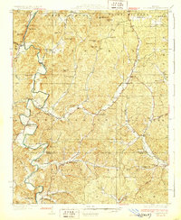
1933 Map of Marquand
USGS Topo · Published 1973About this map
The Castor River and Crooked Creek corridors define this 1933 topographical survey of the Missouri Ozarks borderlands, where Madison and Bollinger counties meet. The landscape is dotted with small-scale mineral extraction sites like the Starkey Mine and Cozean Mine, alongside a dense network of country schools such as Shelley Creek Sch and Allbright Sch. These features reflect a rural economy transitioning from timber and mining to more established agriculture during the early twentieth century.
Find a feature on this map
104 named features on this map. Tap any name to fly to it.
Don’t see what you’re looking for? This feature index may not catch every label — zoom into the map to look around manually.
Map Details
Editions of this 1933 Marquand Map
2 editions found
Other maps of this area

1910 · Higdon
USGS Topo · 1:62,500

1923 · Perryville
USGS Topo · 1:62,500

1924 · Perryville
USGS Topo · 1:62,500
1930 · Coldwater
USGS Topo · 1:62,500

1933 · Marble Hill
USGS Topo · 1:62,500

1933 · Marquand
USGS Topo · 1:62,500
1934 · Greenville
USGS Topo · 1:62,500

1934 · Advance
USGS Topo · 1:62,500
1935 · Zalma
USGS Topo · 1:62,500
1937 · Marble Hill
USGS Topo · 1:62,500