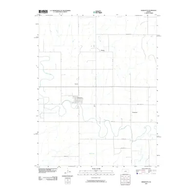
2009 Map of Marquette
USGS Topo · Published 2009About this map
The Smoky Hill River meanders across this landscape, providing a winding geographical anchor for the town of Marquette. This central Kansas settlement is defined by a grid of numbered streets and avenues, including 6th St and 6th Ave, which serve as local conduits for the surrounding agricultural community. The map reveals the placement of essential local landmarks such as the Marquette Cemetery, located just north of the town center, and the small outlying communities of Mackie and Freemount. The terrain is etched with numerous drainages, such as Wolf Creek and West Dry Creek, which feed into the larger river system. A network of rural roads, including Smoky Valley Rd and Winchester Rd, connects these remote outposts, reflecting the enduring rural structure of McPherson County.
Find a feature on this map
23 named features on this map. Tap any name to fly to it.
Don’t see what you’re looking for? This feature index may not catch every label — zoom into the map to look around manually.
Map Details
Editions of this 2009 Marquette Map
This is the sole edition of this map. No revisions or reprints were ever made.
Other maps of this area

1891 · Hutchinson
USGS Topo · 1:125,000

1892 · Salina
USGS Topo · 1:125,000

1893 · Hutchinson
USGS Topo · 1:125,000

1942 · Salina
USGS Topo · 1:125,000

1955 · Smolan
USGS Topo · 1:24,000

1955 · Falun
USGS Topo · 1:24,000

1955 · Hutchinson
USGS Topo · 1:250,000
1957 · Venango
USGS Topo · 1:24,000

1959 · Hutchinson
USGS Topo · 1:250,000

1964 · Marquette
USGS Topo · 1:24,000