
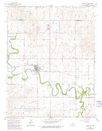
1964 Map of Marquette
USGS Topo · Published 1965About this map
The Smoky Hill River meanders sharply through the central Kansas plains, anchoring the small grid of Marquette. This mid-century landscape is defined by the intersection of the Missouri Pacific railroad and a agricultural river economy. To the north, the small siding of Mackie and various Gravel Pits suggest the area's industrial activity, while the southern reaches near Edwards and Sharps Creek transition into more open terrain. Local heritage is concentrated at landmarks like Freemount Ch and the Marquette Cem, providing valuable points of reference for genealogists. The map illustrates a rural society built on the fertile bottomlands, where even small features like the local Sandpit and Sewage Disposal facility speak to the town's self-contained infrastructure during the 1960s.
Find a feature on this map
21 named features on this map. Tap any name to fly to it.
Don’t see what you’re looking for? This feature index may not catch every label — zoom into the map to look around manually.
Map Details
Editions of this 1964 Marquette Map
2 editions found
Other maps of this area

1891 · Hutchinson
USGS Topo · 1:125,000

1892 · Salina
USGS Topo · 1:125,000

1893 · Hutchinson
USGS Topo · 1:125,000

1942 · Salina
USGS Topo · 1:125,000

1955 · Smolan
USGS Topo · 1:24,000

1955 · Falun
USGS Topo · 1:24,000

1955 · Hutchinson
USGS Topo · 1:250,000
1957 · Venango
USGS Topo · 1:24,000

1959 · Hutchinson
USGS Topo · 1:250,000
1964 · Langley
USGS Topo · 1:24,000