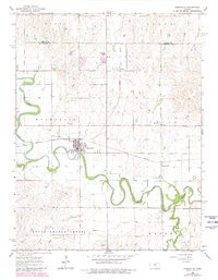
1964 Map of Marquette
USGS Topo · Published 1980About this map
The Smoky Hill River carves a winding path through the heart of this McPherson County landscape, dictating the development of local transport and settlement. The town of Marquette serves as the primary hub, situated where the Missouri Pacific railroad crosses the river. This rail line connects the rural outposts of Mackie and Freemount, the latter characterized by the local Freemount Ch. The survey captures the transition of the late 1950s into the 1960s, with later revisions in 1978 highlighting changes in land use, such as several gravel pits and sandpits near the riverbanks. To the south, Sharps Creek and Edwards mark the more dispersed agricultural portions of the territory, while the Marquette Cem stands as a primary genealogical landmark for the region.
Find a feature on this map
21 named features on this map. Tap any name to fly to it.
Don’t see what you’re looking for? This feature index may not catch every label — zoom into the map to look around manually.
Map Details
Editions of this 1964 Marquette Map
2 editions found
Other maps of this area

1891 · Hutchinson
USGS Topo · 1:125,000

1892 · Salina
USGS Topo · 1:125,000

1893 · Hutchinson
USGS Topo · 1:125,000

1942 · Salina
USGS Topo · 1:125,000

1955 · Smolan
USGS Topo · 1:24,000

1955 · Falun
USGS Topo · 1:24,000

1955 · Hutchinson
USGS Topo · 1:250,000
1957 · Venango
USGS Topo · 1:24,000

1959 · Hutchinson
USGS Topo · 1:250,000

1964 · Marquette
USGS Topo · 1:24,000