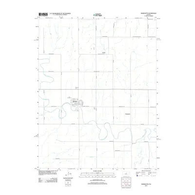
2012 Map of Marquette
USGS Topo · Published 2012About this map
Marquette centers this Central Kansas landscape, where the town grid is defined by streets like W 2nd St and S Elm St near the local Post Office. The Smoky Hill River meanders broadly through the territory, joined by tributaries including Wolf Cr and Edwards Cr. This drainage system influenced the placement of early settlements and rural cemeteries, such as the Marquette Cem and Elim Lutheran Cem, which serve as vital markers for genealogical research. Small crossroads locations like Mackie and Freemount anchor the surrounding agricultural sections. The road network, comprising named routes like W Coronado Heights Rd and Smoky Valley Rd, reflects the established section-line grid typical of the region's development.
Find a feature on this map
42 named features on this map. Tap any name to fly to it.
Don’t see what you’re looking for? This feature index may not catch every label — zoom into the map to look around manually.
Map Details
Editions of this 2012 Marquette Map
This is the sole edition of this map. No revisions or reprints were ever made.
Other maps of this area

1891 · Hutchinson
USGS Topo · 1:125,000

1892 · Salina
USGS Topo · 1:125,000

1893 · Hutchinson
USGS Topo · 1:125,000

1942 · Salina
USGS Topo · 1:125,000

1955 · Smolan
USGS Topo · 1:24,000

1955 · Falun
USGS Topo · 1:24,000

1955 · Hutchinson
USGS Topo · 1:250,000
1957 · Venango
USGS Topo · 1:24,000

1959 · Hutchinson
USGS Topo · 1:250,000

1964 · Marquette
USGS Topo · 1:24,000