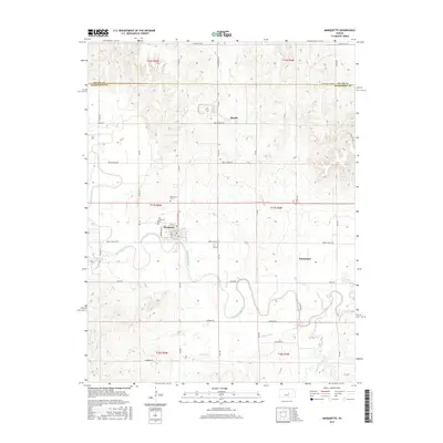
2015 Map of Marquette
USGS Topo · Published 2015About this map
Marquette serves as the primary hub of this McPherson County landscape, situated along the northern banks of the meandering Smoky Hill River. The town's grid is dense with local history markers, including the central Po and the nearby Marquette Cemetery. To the north, the small settlement of Mackie sits at the intersection of Wheatridge Road and South Soderberg Road, while Freemount occupies the eastern prairie lands. This 2015 survey illustrates a rural Kansas environment defined by its watercourses, from the larger river to smaller tributaries like Edwards Creek, Sharps Creek, and Wolf Creek. The area's spiritual and genealogical heritage is centered at the Elim Lutheran Cemetery, located just north of the Marquette town limits. A network of country roads, including Wells Fargo Road and Coronado Heights Road, connects the scattered farmsteads and agricultural sections.
Find a feature on this map
29 named features on this map. Tap any name to fly to it.
Don’t see what you’re looking for? This feature index may not catch every label — zoom into the map to look around manually.
Map Details
Editions of this 2015 Marquette Map
This is the sole edition of this map. No revisions or reprints were ever made.
Other maps of this area

1891 · Hutchinson
USGS Topo · 1:125,000

1892 · Salina
USGS Topo · 1:125,000

1893 · Hutchinson
USGS Topo · 1:125,000

1942 · Salina
USGS Topo · 1:125,000

1955 · Smolan
USGS Topo · 1:24,000

1955 · Falun
USGS Topo · 1:24,000

1955 · Hutchinson
USGS Topo · 1:250,000
1957 · Venango
USGS Topo · 1:24,000

1959 · Hutchinson
USGS Topo · 1:250,000

1964 · Marquette
USGS Topo · 1:24,000