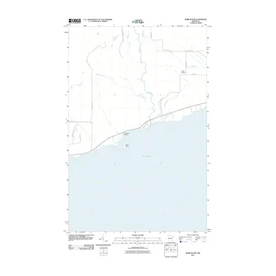
2011 Map of Marr Island
USGS Topo · Published 2011About this map
Judge Magney State Park defines the northern reaches of this Lake Superior shoreline in Cook County, where the Brule River and Gauthier Creek cut through the timbered landscape toward the coast. This 2011 survey captures a transitional coastal geography, marked by the presence of Paradise Beach and its namesake Marr Island just offshore. The map provides a clear picture of the local road network that supports this rural area, including Manitou Trl and Caspers Hill Rd, alongside family-named landmarks like Kellys Hl. For genealogists and local historians, the inclusion of the Trinity Lutheran Cemetery near Flute Reed Rd offers a specific point of interest for tracing family roots in this corner of Northeast Minnesota.
Find a feature on this map
19 named features on this map. Tap any name to fly to it.
Don’t see what you’re looking for? This feature index may not catch every label — zoom into the map to look around manually.
Map Details
Editions of this 2011 Marr Island Map
This is the sole edition of this map. No revisions or reprints were ever made.
Other maps of this area

1954 · Two Harbors
USGS Topo · 1:250,000

1957 · Two Harbors
USGS Topo · 1:250,000

1958 · Two Harbors
USGS Topo · 1:250,000

1958 · Hancock
USGS Topo · 1:250,000

1959 · Northern Light Lake
USGS Topo · 1:24,000

1959 · Tom Lake
USGS Topo · 1:24,000

1960 · Hancock
USGS Topo · 1:250,000
1960 · Farquhar Peak
USGS Topo · 1:24,000
1960 · Hovland
USGS Topo · 1:24,000
1960 · Kadunce Creek
USGS Topo · 1:24,000