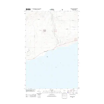
2013 Map of Marr Island
USGS Topo · Published 2013About this map
The rocky North Shore of Lake Superior meets the densely forested uplands of Superior National Forest on this 2013 survey. The landscape is defined by the sharp transition from the shoreline at Paradise Beach to the rising elevations of Bloomquist Mountain and Caspers Hill. This section of Cook County is characterized by a network of drainage systems, including the Brule River and Flute Reed River, which carve through the terrain toward the lake. While the coastal corridor is navigated by MN-61, more primitive routes like Manitou Trl and Camp 20 Rd reach into the interior. Local history is anchored by the Trinity Lutheran Cem located inland, while the eponymous Marr Island sits just offshore, marking a distinctive landmark in this relatively unpopulated stretch of the Minnesota coast.
Find a feature on this map
21 named features on this map. Tap any name to fly to it.
Don’t see what you’re looking for? This feature index may not catch every label — zoom into the map to look around manually.
Map Details
Editions of this 2013 Marr Island Map
This is the sole edition of this map. No revisions or reprints were ever made.
Other maps of this area

1954 · Two Harbors
USGS Topo · 1:250,000

1957 · Two Harbors
USGS Topo · 1:250,000

1958 · Two Harbors
USGS Topo · 1:250,000

1958 · Hancock
USGS Topo · 1:250,000

1959 · Northern Light Lake
USGS Topo · 1:24,000

1959 · Tom Lake
USGS Topo · 1:24,000

1960 · Hancock
USGS Topo · 1:250,000
1960 · Farquhar Peak
USGS Topo · 1:24,000
1960 · Hovland
USGS Topo · 1:24,000
1960 · Kadunce Creek
USGS Topo · 1:24,000