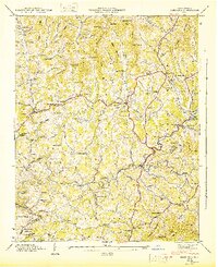
1946 Map of Mars Hill
USGS Topo · Published 1947About this map
Mars Hill serves as the focal point of this mid-1940s topography, showing a landscape defined by deeply cut creek valleys and narrow mountain ridges along the Madison and Buncombe county line. The settlement pattern follows the water, with homes and institutions clustered along Bull Creek and Gabriel Creek. This era of documentation reveals a high density of rural infrastructure, from the Palmer Ford Bridge crossing the French Broad River in the southwest to the Ivy Post Office in the east. Numerous family-named cemeteries such as Sams Cem, Ray Cem, and Mc Elroy Cem are meticulously plotted alongside small community centers like Jupiter, Flat Creek, and Beech Glen. The map captures the transition from isolated mountain hollows to a more connected rural network, anchored by significant local landmarks like the Old Bull Creek Ch and the Bull Creek Sch.
Find a feature on this map
125 named features on this map. Tap any name to fly to it.
Don’t see what you’re looking for? This feature index may not catch every label — zoom into the map to look around manually.
Map Details
Editions of this 1946 Mars Hill Map
This is the sole edition of this map. No revisions or reprints were ever made.
Other maps of this area

1894 · Asheville
USGS Topo · 1:125,000

1900 · Mount Mitchell
USGS Topo · 1:125,000

1901 · Asheville
USGS Topo · 1:125,000

1902 · Mount Mitchell
USGS Topo · 1:125,000

1935 · Bald Creek
USGS Topo · 1:24,000

1935 · Barnardsville
USGS Topo · 1:24,000

1935 · Craggy Pinnacle
USGS Topo · 1:24,000

1936 · Marshall
USGS Topo · 1:24,000

1936 · Sams Gap
USGS Topo · 1:24,000

1936 · White Rock
USGS Topo · 1:24,000