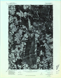
1975 Map of Mars Hill SE
USGS Topo · Published 1981About this map
The international border between the United States and Canada bisects this orthophotograph, capturing the agricultural and wooded landscape of Aroostook County during the mid-1970s. The terrain is dominated by the prominent rise of Mars, overlooking a grid of farm fields and dense woodlots that define the regional economy. To the southwest, the town centers of Mars Hill and Blaine appear as concentrated hubs of development along the transportation corridors that follow the water of Prestile and Rocky. Across the boundary into New Brunswick, smaller settlements like Listerville and Upper Knoxford are visible, highlighting the shared geography and rural character that transcends the national line. The imagery provides a clear view of land-use patterns, showing the sharp contrast between cleared agricultural plots and the remaining forest cover during this period.
Find a feature on this map
11 named features on this map. Tap any name to fly to it.
Don’t see what you’re looking for? This feature index may not catch every label — zoom into the map to look around manually.
Map Details
Editions of this 1975 Mars Hill SE Map
This is the sole edition of this map. No revisions or reprints were ever made.
Other maps of this area

1934 · Bridgewater
USGS Topo · 1:48,000

1936 · Mars Hill
USGS Topo · 1:48,000

1938 · Bridgewater
USGS Topo · 1:62,500

1940 · Mars Hill
USGS Topo · 1:62,500

1951 · Mars Hill
USGS Topo · 1:62,500

1951 · Bridgewater
USGS Topo · 1:62,500

1953 · Bridgewater
USGS Topo · 1:50,000

1959 · Woodstock
USGS Topo · 1:250,000

1963 · Woodstock
USGS Topo · 1:250,000
1975 · Mars Hill NW
USGS Topo · 1:24,000