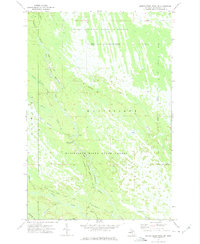
1972 Map of Marsh Creek Pool NW
USGS Topo · Published 1975About this map
The Seney National Wildlife Refuge and Manistique River State Forest dominate this Upper Peninsula landscape, showcasing a complex hydrology of rivers and marshy lowlands in Schoolcraft County. The area is defined by the winding course of the West Branch Manistique River, which is joined by numerous tributaries including Hickey Creek, Duck Creek, and Section Nineteen Creek. These waterways, along with the Walsh Ditch in the northeast, illustrate the historical efforts to manage drainage and conservation across these protected lands.
Find a feature on this map
28 named features on this map. Tap any name to fly to it.
Don’t see what you’re looking for? This feature index may not catch every label — zoom into the map to look around manually.
Map Details
Editions of this 1972 Marsh Creek Pool NW Map
2 editions found
Other maps of this area

1931 · Steuben SE
USGS Topo · 1:31,680

1931 · Manistique River NE
USGS Topo · 1:31,680

1931 · Steuben NE
USGS Topo · 1:31,680

1931 · Manistique River SE
USGS Topo · 1:31,680

1931 · Manistique River NW
USGS Topo · 1:31,680

1931 · Shingleton SE
USGS Topo · 1:31,680

1931 · Manistique River SW
USGS Topo · 1:31,680

1931 · Driggs Lake SW
USGS Topo · 1:31,680

1931 · Driggs Lake SE
USGS Topo · 1:31,680

1958 · Shingleton
USGS Topo · 1:62,500