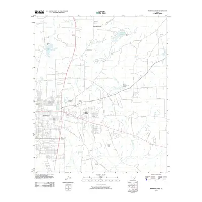
2010 Map of Marshall East
USGS Topo · Published 2010About this map
The eastern edges of Marshall and the surrounding Harrison County landscape are defined by a complex network of small cemeteries and local water management features. The Ginocchio Historic District anchors the western side of the sheet, while residential pockets like Jasper Heights, Gainesville, and Bel Air extend into the countryside. This area is notably dense with burial grounds, including Greenwood Cemetery, Algoma Cemetery, and Saint Joseph Cemetery, providing a significant record for genealogical research in East Texas.
Find a feature on this map
76 named features on this map. Tap any name to fly to it.
Don’t see what you’re looking for? This feature index may not catch every label — zoom into the map to look around manually.
Map Details
Editions of this 2010 Marshall East Map
This is the sole edition of this map. No revisions or reprints were ever made.
Other maps of this area

1943 · Waskom
USGS Topo · 1:62,500

1944 · Caddo Lake
USGS Topo · 1:62,500

1945 · Waskom
USGS Topo · 1:62,500

1946 · Caddo Lake
USGS Topo · 1:62,500

1956 · Tyler
USGS Topo · 1:250,000

1958 · Darco
USGS Topo · 1:62,500

1962 · Marshall NW
USGS Topo · 1:24,000

1962 · Marshall West
USGS Topo · 1:24,000

1962 · Woodlawn
USGS Topo · 1:24,000
1962 · Karnack
USGS Topo · 1:24,000