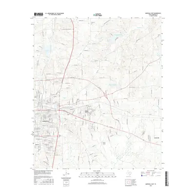
2016 Map of Marshall East
USGS Topo · Published 2016About this map
Marshall serves as the focal point of this East Texas survey, revealing a landscape defined by its transition from a structured urban center to the surrounding rural reaches of Harrison County. The city's residential growth is evidenced by neighborhoods like Jasper Heights and Bel Air, while the outlying areas maintain a traditional East Texas character with numerous family and community burial grounds, including Algoma Cem and Gainesville Cem. The terrain is deeply carved by waterways such as Eightmile Cr and Deboldin Cr, which influence the winding paths of local roads like Munden Dance Hall Rd and Henderson School House Rd. Infrastructure like the Harrison County Airport and the expansive Marshall Lakeside Country Club Lake highlight the mid-century development patterns that expanded the town's footprint toward Scottsville in the east.
Find a feature on this map
156 named features on this map. Tap any name to fly to it.
Don’t see what you’re looking for? This feature index may not catch every label — zoom into the map to look around manually.
Map Details
Editions of this 2016 Marshall East Map
This is the sole edition of this map. No revisions or reprints were ever made.
Other maps of this area

1943 · Waskom
USGS Topo · 1:62,500

1944 · Caddo Lake
USGS Topo · 1:62,500

1945 · Waskom
USGS Topo · 1:62,500

1946 · Caddo Lake
USGS Topo · 1:62,500

1956 · Tyler
USGS Topo · 1:250,000

1958 · Darco
USGS Topo · 1:62,500

1962 · Marshall NW
USGS Topo · 1:24,000

1962 · Marshall West
USGS Topo · 1:24,000

1962 · Woodlawn
USGS Topo · 1:24,000
1962 · Karnack
USGS Topo · 1:24,000