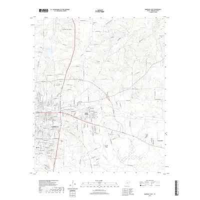
2019 Map of Marshall East
USGS Topo · Published 2019About this map
Marshall and its eastern surroundings are characterized by a dense network of suburban developments and essential regional infrastructure. The urban grid transitions into residential enclaves like Jasper Heights, Bel Air, and Suburban Acres, while the Harrison County Airport serves as a major hub for the area's transportation needs. This landscape is also a repository of local heritage, marked by numerous burial grounds such as Saint Joseph Cem, Algoma Cem, and the more remote Sherrod Cem.
Find a feature on this map
179 named features on this map. Tap any name to fly to it.
Don’t see what you’re looking for? This feature index may not catch every label — zoom into the map to look around manually.
Map Details
Editions of this 2019 Marshall East Map
This is the sole edition of this map. No revisions or reprints were ever made.
Other maps of this area

1943 · Waskom
USGS Topo · 1:62,500

1944 · Caddo Lake
USGS Topo · 1:62,500

1945 · Waskom
USGS Topo · 1:62,500

1946 · Caddo Lake
USGS Topo · 1:62,500

1956 · Tyler
USGS Topo · 1:250,000

1958 · Darco
USGS Topo · 1:62,500

1962 · Marshall NW
USGS Topo · 1:24,000

1962 · Marshall West
USGS Topo · 1:24,000

1962 · Woodlawn
USGS Topo · 1:24,000
1962 · Karnack
USGS Topo · 1:24,000