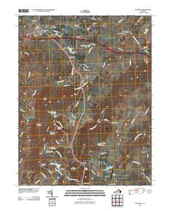
2010 Map of Marshall
USGS Topo · Published 2010About this map
Wildcat Mountain and Pignut Mountain rise above a landscape defined by the intersection of traditional Piedmont crossroads and modern infrastructure. This 2010 survey shows the northern Fauquier County area centered around Marshall and The Plains, where historical hamlets like Old Tavern, Edwardsville, and Meadowville continue to mark the road network. The map records a transition from the rolling terrain around Stephensons Hill and Piedmont Heights to the specialized land use seen at The Meadows Airport and Airlie Airport. Water features such as Broad Run, Carter Run, and Merry Oak Lake illustrate the local drainage patterns, while the concentration of labeled properties and named roads like Old Thoroughfare Gap Rd and Cannonball Ridge Ln provides valuable data for researchers studying the evolving character of northern Virginia’s rural and residential communities.
Find a feature on this map
77 named features on this map. Tap any name to fly to it.
Don’t see what you’re looking for? This feature index may not catch every label — zoom into the map to look around manually.
Map Details
Editions of this 2010 Marshall Map
This is the sole edition of this map. No revisions or reprints were ever made.
Other maps of this area

1894 · Warrenton
USGS Topo · 1:125,000

1894 · Warrenton
USGS Topo · 1:62,500

1927 · Remington
USGS Topo · 1:48,000

1930 · Warrenton
USGS Topo · 1:62,500

1933 · Middleburg
USGS Topo · 1:62,500

1943 · Catlett
USGS Topo · 1:62,500

1943 · Thorofare Gap
USGS Topo · 1:24,000

1943 · Orlean
USGS Topo · 1:24,000

1943 · Marshall
USGS Topo · 1:24,000

1943 · Upperville
USGS Topo · 1:24,000