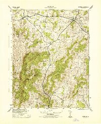
1944 Map of Marshall
USGS Topo · Published 1944About this map
Southern railroad tracks bisect the northern half of this Fauquier County landscape, connecting the village of Marshall with The Plains and Belvoir. The terrain is defined by the significant ridges of Mother Leathercoat Mountain and Pignut Mountain, which force the road network into the valleys near Broad Run and Carter Run. This 1940s War Department survey illustrates a rural community anchored by small rural institutions, including Public School No 18, Foster Hill School, and the Bethel School in the south near Bethel Church. Local social gathering points like the Fair Grounds near Marshall and the crossroads at Old Tavern suggest the established social patterns of the Virginia hunt country before mid-century modernization. Multiple stream crossings and fords are visible along Little River and Trap Branch, marking the old travel routes between family holdings such as Foster Fork.
Find a feature on this map
23 named features on this map. Tap any name to fly to it.
Don’t see what you’re looking for? This feature index may not catch every label — zoom into the map to look around manually.
Map Details
Editions of this 1944 Marshall Map
This is the sole edition of this map. No revisions or reprints were ever made.
Other maps of this area

1894 · Warrenton
USGS Topo · 1:125,000

1894 · Warrenton
USGS Topo · 1:62,500

1927 · Remington
USGS Topo · 1:48,000

1930 · Warrenton
USGS Topo · 1:62,500

1933 · Middleburg
USGS Topo · 1:62,500

1943 · Catlett
USGS Topo · 1:62,500

1943 · Thorofare Gap
USGS Topo · 1:24,000

1943 · Orlean
USGS Topo · 1:24,000

1943 · Marshall
USGS Topo · 1:24,000

1943 · Upperville
USGS Topo · 1:24,000