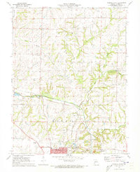
1971 Map of Marshall North
USGS Topo · Published 1973About this map
Fairville and the northern outskirts of the city of Marshall define this 1970s landscape in Saline County. The area is characterized by a transition from the structured urban layout of the county seat to the agrarian terrain of northern townships like Miami. Heavy infrastructure is prominent, with the Gulf Mobile And Ohio railroad cutting through the territory and multiple communication sites such as the Radio Tower (KMMO).
Find a feature on this map
25 named features on this map. Tap any name to fly to it.
Don’t see what you’re looking for? This feature index may not catch every label — zoom into the map to look around manually.
Map Details
Editions of this 1971 Marshall North Map
2 editions found
Other maps of this area

1890 · Marshall
USGS Topo · 1:125,000

1892 · Marshall
USGS Topo · 1:125,000

1901 · Marshall
USGS Topo · 1:125,000

1940 · Marshall
USGS Topo · 1:62,500

1944 · Marshall
USGS Topo · 1:62,500

1951 · Miami
USGS Topo · 1:24,000

1951 · Miami Station
USGS Topo · 1:24,000
1951 · New Frankfort
USGS Topo · 1:24,000

1953 · Moberly
USGS Topo · 1:250,000
1953 · Shackleford
USGS Topo · 1:24,000