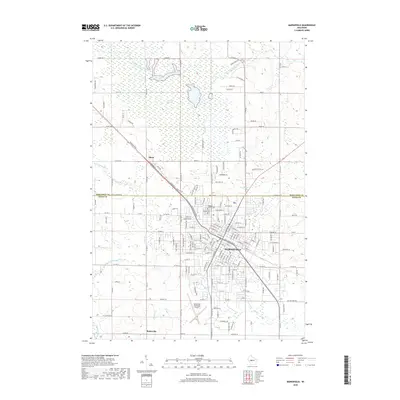
2018 Map of Marshfield
USGS Topo · Published 2018About this map
The expansive McMillan Marsh dominates the northern landscape of this central Wisconsin region, where the Little Eau Pleine River winds through the wetlands near the Marathon Co and Wood Co border. The city of Marshfield serves as the central hub, showing its established street grid and key local landmarks like Hillside Cem and the Gates of Heaven Cem. To the south and west, the terrain transitions into a patchwork of agricultural lands and smaller rural settlements such as Mann and Bakerville. This 2018 survey reveals the contemporary infrastructure of the area, including the Marshfield Municipal Airport and a network of county highways that bridge the various branches of the Yellow River and Beaver Cr. The interplay between the industrial and residential core of the city and the surrounding natural drainage basins is clearly defined.
Find a feature on this map
175 named features on this map. Tap any name to fly to it.
Don’t see what you’re looking for? This feature index may not catch every label — zoom into the map to look around manually.
Map Details
Editions of this 2018 Marshfield Map
This is the sole edition of this map. No revisions or reprints were ever made.
Other maps of this area

1902 · Marathon
USGS Topo · 1:125,000

1953 · Abbotsford
USGS Topo · 1:48,000

1953 · Stratford
USGS Topo · 1:48,000

1953 · Eau Claire
USGS Topo · 1:250,000

1954 · Granton
USGS Topo · 1:62,500

1954 · Marshfield
USGS Topo · 1:62,500

1958 · Eau Claire
USGS Topo · 1:250,000

1963 · Stratford
USGS Topo · 1:62,500

1963 · Abbotsford
USGS Topo · 1:62,500

1964 · Eau Claire
USGS Topo · 1:250,000