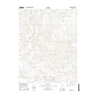
2015 Map of Marthasville
USGS Topo · Published 2015About this map
Marthasville and the agricultural lands of La Charrette Bottom anchor the southern portion of this landscape, where the Missouri River floodplain transitions into the rising terrain of Tuque Ridge. The settlement of Peers sits near the western edge, connected by the historic rail-to-trail route of the Katy Trl and the wetlands of Peers Slough. To the north, the modern resort community of Innsbrook is defined by residential development around Wonder Lake and Wildwood Lakes, contrasting with the more traditional rural patterns found along Charrette Creek. The map documents a diverse topography, including the deeply incised feature known as the Grand Canyon and the winding course of Tuque Cr. Local landmarks like Engemann Spring and legacy road names such as Dreye School Rd provide specific touchpoints for those tracing family history or the evolution of Warren County's rural infrastructure.
Find a feature on this map
98 named features on this map. Tap any name to fly to it.
Don’t see what you’re looking for? This feature index may not catch every label — zoom into the map to look around manually.
Map Details
Editions of this 2015 Marthasville Map
This is the sole edition of this map. No revisions or reprints were ever made.
Other maps of this area

1890 · Hermann
USGS Topo · 1:125,000

1903 · O'Fallon
USGS Topo · 1:125,000

1941 · Troy
USGS Topo · 1:62,500

1943 · Warrenton
USGS Topo · 1:62,500

1945 · Troy
USGS Topo · 1:62,500

1945 · Warrenton
USGS Topo · 1:62,500

1948 · Washington
USGS Topo · 1:62,500

1948 · Augusta
USGS Topo · 1:62,500

1949 · Saint Louis
USGS Topo · 1:250,000
1949 · Washington
USGS Topo · 1:62,500