
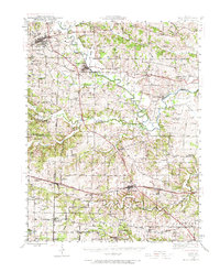
1941 Map of Troy
USGS Topo · Published 1964About this map
The Cuivre River winds through the heart of this landscape, marking the boundary between Lincoln and St. Charles Counties in the early 1940s. The region is characterized by a dense network of rural one-room schoolhouses, including Pond Fort Sch and Sugar Grove Sch, which speak to the decentralized community life of the era. Settlement is anchored by larger hubs like Troy and Wentzville, the latter serving as a critical junction for the Wabash RR.
Find a feature on this map
77 named features on this map. Tap any name to fly to it.
Don’t see what you’re looking for? This feature index may not catch every label — zoom into the map to look around manually.
Map Details
Editions of this 1941 Troy Map
2 editions found
Other maps of this area

1890 · Louisiana
USGS Topo · 1:125,000

1890 · Hermann
USGS Topo · 1:125,000

1903 · O'Fallon
USGS Topo · 1:125,000

1930 · Hardin
USGS Topo · 1:62,500

1931 · Brussels
USGS Topo · 1:62,500

1934 · Elsberry
USGS Topo · 1:48,000

1934 · Hardin
USGS Topo · 1:62,500

1937 · Weldon Spring
USGS Topo · 1:24,000

1937 · Silex
USGS Topo · 1:62,500

1938 · Hardin
USGS Topo · 1:62,500