
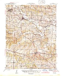
1945 Map of Troy
USGS Topo · Published 1945About this map
The Cuivre River and its numerous tributaries, including Big Creek and Crooked Creek, define the landscape of eastern Missouri as it appeared in the early 1940s. A dense network of rural infrastructure is visible, with dozens of family-named schools like Whitcomb Sch and Keelstone Sch serving the farming communities. The Cuivre River Recreational Area occupies a significant portion of the northern terrain, while the southern reaches show the early residential patterns of Wentzville and Foristell.
Find a feature on this map
84 named features on this map. Tap any name to fly to it.
Don’t see what you’re looking for? This feature index may not catch every label — zoom into the map to look around manually.
Map Details
Editions of this 1945 Troy Map
2 editions found
Other maps of this area

1890 · Louisiana
USGS Topo · 1:125,000

1890 · Hermann
USGS Topo · 1:125,000

1903 · O'Fallon
USGS Topo · 1:125,000

1930 · Hardin
USGS Topo · 1:62,500

1931 · Brussels
USGS Topo · 1:62,500

1934 · Elsberry
USGS Topo · 1:48,000

1934 · Hardin
USGS Topo · 1:62,500

1937 · Weldon Spring
USGS Topo · 1:24,000

1937 · Silex
USGS Topo · 1:62,500

1938 · Hardin
USGS Topo · 1:62,500