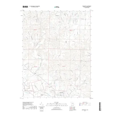
2017 Map of Marthasville
USGS Topo · Published 2017About this map
Marthasville anchors the southern portion of this Warren County landscape, situated just north of the extensive alluvial plains of La Charrette Bottom. This 2017 survey reveals a diverse topography, where the Missouri River valley floor meets the rising elevations of Peers Bluff and Timber Ridge. The settlement of Peers sits along the southwestern edge near Peers Slough, while the planned community of Innsbrook occupies the northern reaches of the quadrangle, characterized by numerous small impoundments such as Wonder Lake and Wildwood Lakes.
Find a feature on this map
96 named features on this map. Tap any name to fly to it.
Don’t see what you’re looking for? This feature index may not catch every label — zoom into the map to look around manually.
Map Details
Editions of this 2017 Marthasville Map
This is the sole edition of this map. No revisions or reprints were ever made.
Other maps of this area

1890 · Hermann
USGS Topo · 1:125,000

1903 · O'Fallon
USGS Topo · 1:125,000

1941 · Troy
USGS Topo · 1:62,500

1943 · Warrenton
USGS Topo · 1:62,500

1945 · Troy
USGS Topo · 1:62,500

1945 · Warrenton
USGS Topo · 1:62,500

1948 · Washington
USGS Topo · 1:62,500

1948 · Augusta
USGS Topo · 1:62,500

1949 · Saint Louis
USGS Topo · 1:250,000
1949 · Washington
USGS Topo · 1:62,500