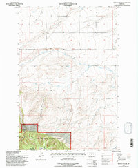
1995 Map of Martin Coulee
USGS Topo · Published 1997About this map
Lewis and Clark National Forest anchors the southern reaches of this landscape, where the terrain shifts from the high, open coulees of central Montana into the timbered slopes of Roughlock Hill. The map documents a rugged drainage network defined by the 3rd Standard Parallel North, featuring the prominent Saager Canyon and the winding course of Martin Coulee. This 1990s revision by the U.S. Forest Service reveals the complex topography of the Judith Basin and Wheatland county line. The land is marked by small-scale resource extraction and essential water sources, including several named springs and numerous Gravel Pits scattered along the drainages of West Buffalo Creek and Coyote Creek. Small mines and cattle-country infrastructure highlight the rural, working character of the region during this era.
Find a feature on this map
23 named features on this map. Tap any name to fly to it.
Don’t see what you’re looking for? This feature index may not catch every label — zoom into the map to look around manually.
Map Details
Editions of this 1995 Martin Coulee Map
This is the sole edition of this map. No revisions or reprints were ever made.
Other maps of this area

1886 · Little Belt Mts.
USGS Topo · 1:250,000

1889 · Big Snowy Mountain
USGS Topo · 1:250,000

1893 · Big Snowy Mountain
USGS Topo · 1:250,000

1894 · Little Belt Mts.
USGS Topo · 1:250,000

1897 · Little Belt Mts.
USGS Topo · 1:250,000

1898 · Little Belt Mts.
USGS Topo · 1:250,000

1902 · Little Belt Mts.
USGS Topo · 1:250,000

1948 · White Sulphur Springs
USGS Topo · 1:250,000

1954 · Roundup
USGS Topo · 1:250,000

1958 · Roundup
USGS Topo · 1:250,000