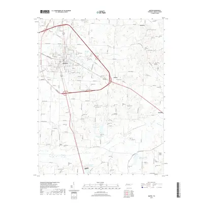
2019 Map of Martin
USGS Topo · Published 2019About this map
Martin serves as the primary hub in this portion of Weakley County, where local roads radiate out toward smaller settlements like Ralston and Dresden. The landscape is defined by the winding paths of Cane Cr and Mud Creek, interspersed with a series of engineered water bodies including W F Baker Lake and several Mud Creek Watershed Lakes. This area is particularly rich in genealogical data, preserving the locations of numerous family-named burial grounds. From the Yellow Fever Cem and Dibrell Cem near the town center to the outlying Rice-Underwood Cem and Crutchfield-Rowlett Cem, these sites offer a clear map of the region's ancestral homesteads. The inclusion of Wayne's World Airport to the southeast provides a modern contrast to the deeply rooted network of rural cemeteries and creek bottoms that have historically shaped this Tennessee landscape.
Find a feature on this map
168 named features on this map. Tap any name to fly to it.
Don’t see what you’re looking for? This feature index may not catch every label — zoom into the map to look around manually.
Map Details
Editions of this 2019 Martin Map
This is the sole edition of this map. No revisions or reprints were ever made.
Other maps of this area

1950 · Martin
USGS Topo · 1:24,000

1952 · Dresden
USGS Topo · 1:24,000

1954 · Rutherford
USGS Topo · 1:24,000

1954 · Greenfield
USGS Topo · 1:24,000

1956 · Gardner
USGS Topo · 1:24,000

1956 · Harris
USGS Topo · 1:24,000

1956 · Mc Connell
USGS Topo · 1:24,000

1956 · Latham
USGS Topo · 1:24,000

1956 · Dyersburg
USGS Topo · 1:250,000

1967 · Pillowville
USGS Topo · 1:24,000