
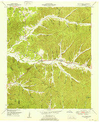
1936 Map of Martins Mills
USGS Topo · Published 1936About this map
Weatherford Creek and Indian Creek dominate this 1930s landscape, where rural life in Wayne County is organized around the intersections of water and community service. The settlement at Martins Mills serves as a central point, supported by its own Martins Mills Sch, while further south, the village of Lutts sits near the crossing of Bear Creek. The map reveals a high density of local educational and spiritual landmarks, including Pinhook Sch, Shady Grove Sch, and the Copeland Chapel. Family and community heritage is deeply etched into the terrain through numerous burial sites like Mt Heber Cem and Nelson Cem. Numerous hollows and branches, such as Smith Hollow and Arnold Branch, define the topography, illustrating a period when small-scale farming and localized community centers were the primary structure of the Tennessee Valley before significant modernization.
Find a feature on this map
50 named features on this map. Tap any name to fly to it.
Don’t see what you’re looking for? This feature index may not catch every label — zoom into the map to look around manually.
Map Details
Editions of this 1936 Martins Mills Map
This is the sole edition of this map. No revisions or reprints were ever made.
Other maps of this area

1905 · Waynesboro
USGS Topo · 1:125,000

1936 · Wolf Pit Ridge
USGS Topo · 1:24,000

1936 · Eagle Creek
USGS Topo · 1:24,000

1936 · Olivehill
USGS Topo · 1:24,000

1936 · Cypress Inn
USGS Topo · 1:24,000

1936 · Three Churches
USGS Topo · 1:24,000

1936 · Ransom Stand
USGS Topo · 1:24,000

1936 · Lowryville
USGS Topo · 1:24,000

1936 · Waynesboro
USGS Topo · 1:24,000
1949 · Eagle Creek
USGS Topo · 1:24,000