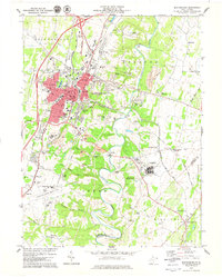
1979 Map of Martinsburg
USGS Topo · Published 1979About this map
Martinsburg serves as the focal point of this late-1970s survey, showing significant urban expansion toward Rosemont and Irish Hill. The landscape is a transition between the concentrated city center and the agricultural reaches of the Shenandoah Valley, marked by the serpentine flow of Opequon Creek and its distinctive Julep Bend. Heavy infrastructure and institutional development are evident, from the sprawling U.S. Veterans Hospital to the West Virginia Regional Airport and the corridor along Interstate 81.
Find a feature on this map
79 named features on this map. Tap any name to fly to it.
Don’t see what you’re looking for? This feature index may not catch every label — zoom into the map to look around manually.
Map Details
Editions of this 1979 Martinsburg Map
This is the sole edition of this map. No revisions or reprints were ever made.
Other maps of this area

1884 · Harpers Ferry
USGS Topo · 1:125,000

1891 · Harpers Ferry
USGS Topo · 1:125,000

1893 · Harpers Ferry
USGS Topo · 1:125,000

1894 · Winchester
USGS Topo · 1:125,000

1899 · Hancock
USGS Topo · 1:62,500

1901 · Hancock
USGS Topo · 1:62,500

1912 · Williamsport
USGS Topo · 1:62,500

1914 · Martinsburg
USGS Topo · 1:48,000

1914 · Gerrardstown
USGS Topo · 1:48,000

1916 · Gerrardstown
USGS Topo · 1:62,500