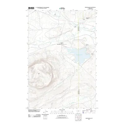
2011 Map of Martinsdale
USGS Topo · Published 2011About this map
Martinsdale sits at the convergence of mountain-fed waters where the North Fork Musselshell River and South Fork Musselshell River meet. This 2011 survey captures the town’s essential infrastructure, including the Martinsdale Post Office and the Martinsdale Fire Service Area, alongside the communal layout of the nearby Martinsdale Colony. The landscape is dominated by the Martinsdale Reservoir, a significant water storage feature supported by the North Martinsdale Dam and East Martinsdale Dam. North of the river, the Gauglerville Cemetery stands as a point of interest for genealogists tracing early families in Meagher County. The terrain transitions from the high vantage of Gordon Butte in the west to the drainages of Little Elk Creek and Gillis Creek, illustrating the hydraulic management required for agriculture and settlement in this part of Montana.
Find a feature on this map
18 named features on this map. Tap any name to fly to it.
Don’t see what you’re looking for? This feature index may not catch every label — zoom into the map to look around manually.
Map Details
Editions of this 2011 Martinsdale Map
This is the sole edition of this map. No revisions or reprints were ever made.
Other maps of this area

1886 · Little Belt Mts.
USGS Topo · 1:250,000

1894 · Little Belt Mts.
USGS Topo · 1:250,000

1897 · Little Belt Mts.
USGS Topo · 1:250,000

1898 · Little Belt Mts.
USGS Topo · 1:250,000

1902 · Little Belt Mts.
USGS Topo · 1:250,000

1948 · White Sulphur Springs
USGS Topo · 1:250,000

1958 · White Sulphur Springs
USGS Topo · 1:250,000

1961 · White Sulphur Springs
USGS Topo · 1:250,000

1965 · White Sulphur Springs
USGS Topo · 1:250,000
1972 · Mud Creek
USGS Topo · 1:24,000