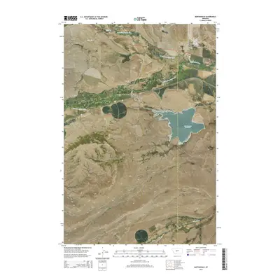
2014 Map of Martinsdale
USGS Topo · Published 2014About this map
The confluence of the N Fork Musselshell River and S Fork Musselshell River anchors this central Montana landscape, where the town of Martinsdale serves as a small hub between the water and the rising terrain of Gordon Butte. This 2014 survey captures a ranching and agricultural landscape defined by the vast Martinsdale Reservoir and the Martinsdale Colony to the northeast. Historical traces include the Gauglierville Cem near the Musselshell River, documenting the lineage of early settlers along the river valley. The map details the transition from the flatlands of Big Coulee to the high ridges of the butte, illustrating how the drainage patterns of Gillis Cr and Little Elk Cr have shaped the placement of roads like Us-12 and MT-294.
Find a feature on this map
23 named features on this map. Tap any name to fly to it.
Don’t see what you’re looking for? This feature index may not catch every label — zoom into the map to look around manually.
Map Details
Editions of this 2014 Martinsdale Map
This is the sole edition of this map. No revisions or reprints were ever made.
Other maps of this area

1886 · Little Belt Mts.
USGS Topo · 1:250,000

1894 · Little Belt Mts.
USGS Topo · 1:250,000

1897 · Little Belt Mts.
USGS Topo · 1:250,000

1898 · Little Belt Mts.
USGS Topo · 1:250,000

1902 · Little Belt Mts.
USGS Topo · 1:250,000

1948 · White Sulphur Springs
USGS Topo · 1:250,000

1958 · White Sulphur Springs
USGS Topo · 1:250,000

1961 · White Sulphur Springs
USGS Topo · 1:250,000

1965 · White Sulphur Springs
USGS Topo · 1:250,000
1972 · Mud Creek
USGS Topo · 1:24,000