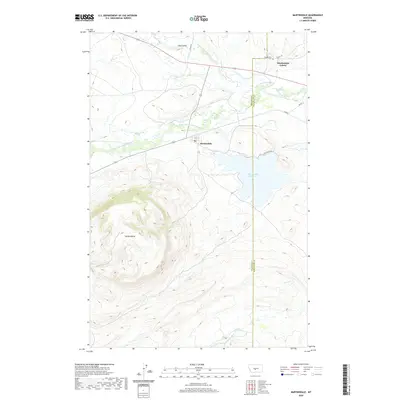
2020 Map of Martinsdale
USGS Topo · Published 2020About this map
The confluence of the N Fork Musselshell River and S Fork Musselshell River anchors this landscape in Meagher County, where the settlement of Martinsdale sits just west of the Wheatland County line. The topography is dominated by the massive profile of Gordon Butte, which rises sharply in the southwestern portion of the quadrangle. North of the town, the Martinsdale Colony and the small locale of Gaugler-ville represent the organized agricultural and residential patterns of the area.
Find a feature on this map
24 named features on this map. Tap any name to fly to it.
Don’t see what you’re looking for? This feature index may not catch every label — zoom into the map to look around manually.
Map Details
Editions of this 2020 Martinsdale Map
This is the sole edition of this map. No revisions or reprints were ever made.
Other maps of this area

1886 · Little Belt Mts.
USGS Topo · 1:250,000

1894 · Little Belt Mts.
USGS Topo · 1:250,000

1897 · Little Belt Mts.
USGS Topo · 1:250,000

1898 · Little Belt Mts.
USGS Topo · 1:250,000

1902 · Little Belt Mts.
USGS Topo · 1:250,000

1948 · White Sulphur Springs
USGS Topo · 1:250,000

1958 · White Sulphur Springs
USGS Topo · 1:250,000

1961 · White Sulphur Springs
USGS Topo · 1:250,000

1965 · White Sulphur Springs
USGS Topo · 1:250,000
1972 · Mud Creek
USGS Topo · 1:24,000