1972 Map of Martinsdale
USGS Topo · Published 1976About this map
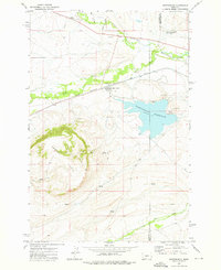
Martinsdale and the nearby Martinsdale Colony anchor this central Montana landscape where the North Fork Musselshell River and South Fork converge. The topography is dominated by the massive Gordon Butte to the southwest, while the human footprint is defined by the Chicago Milwaukee St Paul and Pacific railroad line cutting through the valley. The presence of an Aqueduct feeding into the large Martinsdale Reservoir highlights the critical role of water management in this high-plains environment during the early 1970s. Local history is preserved in the location of a Cem (cemetery) north of the river and several scattered Gravel Pits and Wells, indicating the rural industries and resources of Meagher and Wheatland counties. From the rugged slopes of Gillis to the riparian flats along Little Elk Creek, the map details a ranching and transit corridor at a quiet moment in the late twentieth century.
Find a feature on this map
22 named features on this map. Tap any name to fly to it.
Don’t see what you’re looking for? This feature index may not catch every label — zoom into the map to look around manually.
Map Details
Editions of this 1972 Martinsdale Map
This is the sole edition of this map. No revisions or reprints were ever made.
Other maps of this area

1886 · Little Belt Mts.
USGS Topo · 1:250,000

1894 · Little Belt Mts.
USGS Topo · 1:250,000

1897 · Little Belt Mts.
USGS Topo · 1:250,000

1898 · Little Belt Mts.
USGS Topo · 1:250,000

1902 · Little Belt Mts.
USGS Topo · 1:250,000

1948 · White Sulphur Springs
USGS Topo · 1:250,000

1958 · White Sulphur Springs
USGS Topo · 1:250,000

1961 · White Sulphur Springs
USGS Topo · 1:250,000

1965 · White Sulphur Springs
USGS Topo · 1:250,000

1972 · Mud Creek
USGS Topo · 1:24,000