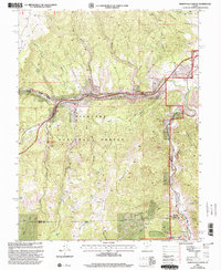
2001 Map of Marysvale Canyon
USGS Topo · Published 2003About this map
Fishlake National Forest defines the high-country landscape of central Utah on this 2001 revision, where the Sevier River carves south through the deep Marysvale Canyon. The topography reveals a land shaped by both geologic force and historic industry, notably at the Yellow Cougar Mine and various prospects near the Sevier and Piute County line. The era's recreational and cultural footprint is evident at Freemont Indian State Park and the famous Big Rock Candy Mountain.
Find a feature on this map
42 named features on this map. Tap any name to fly to it.
Don’t see what you’re looking for? This feature index may not catch every label — zoom into the map to look around manually.
Map Details
Editions of this 2001 Marysvale Canyon Map
This is the sole edition of this map. No revisions or reprints were ever made.
Other maps of this area

1885 · Beaver
USGS Topo · 1:250,000

1932 · Sevier
USGS Topo · 1:62,500

1935 · Sevier
USGS Topo · 1:62,500

1937 · Delano Peak
USGS Topo · 1:48,000

1940 · Monroe
USGS Topo · 1:62,500

1943 · Delano Peak
USGS Topo · 1:62,500

1944 · Monroe
USGS Topo · 1:62,500

1945 · Marysvale
USGS Topo · 1:62,500

1947 · Marysvale
USGS Topo · 1:62,500

1953 · Richfield
USGS Topo · 1:250,000