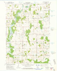
1974 Map of Marytown
USGS Topo · Published 1977About this map
The Manitowoc River and its South Branch cut through a landscape of rolling agriculture and significant limestone quarrying in the mid-1970s. This territory is famously bisected by the Old Indian Treaty Boundary, which runs east-to-west through the center of the sheet, separating the townships of Brothertown and Charlestown to the north from Calumet and Marshfield to the south. Small settlements serve as local hubs, most notably Marytown and Charlesburg, the latter of which includes the St Charles Cem. The heavy presence of several Quarries and Gravel Pits reflects the area's geological utility, while Wayside Park and numerous Springs indicate the natural hydrology of the Calumet and Fond du Lac county line area. The road network is dense with family-named routes such as Pethan Road and Thede Road, tracing the established grid of Wisconsin dairy country.
Find a feature on this map
37 named features on this map. Tap any name to fly to it.
Don’t see what you’re looking for? This feature index may not catch every label — zoom into the map to look around manually.
Map Details
Editions of this 1974 Marytown Map
This is the sole edition of this map. No revisions or reprints were ever made.
Other maps of this area

1910 · Fond du Lac
USGS Topo · 1:62,500

1911 · Neenah
USGS Topo · 1:62,500

1954 · Chilton
USGS Topo · 1:62,500

1954 · Kiel
USGS Topo · 1:62,500

1955 · Neenah
USGS Topo · 1:62,500

1955 · Fond Du Lac
USGS Topo · 1:62,500

1955 · Green Bay
USGS Topo · 1:250,000

1957 · Madison
USGS Topo · 1:250,000

1960 · Madison
USGS Topo · 1:250,000

1974 · St. Cloud
USGS Topo · 1:24,000