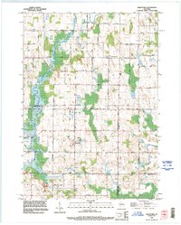
1992 Map of Marytown
USGS Topo · Published 1996About this map
Marytown and Charlesburg anchor this rural landscape in the early 1990s, where the agricultural grid is interrupted by historical survey lines and pockets of local industry. A prominent diagonal Old Indian Treaty Boundary cuts through the western sections of Brothertown, marking a distinct shift in the land division pattern. The map reveals the community centers of the era, from the Saint Charles Cemetery north of the village to the Athletic Field situated near the heart of Marytown.
Find a feature on this map
38 named features on this map. Tap any name to fly to it.
Don’t see what you’re looking for? This feature index may not catch every label — zoom into the map to look around manually.
Map Details
Editions of this 1992 Marytown Map
This is the sole edition of this map. No revisions or reprints were ever made.
Other maps of this area

1910 · Fond du Lac
USGS Topo · 1:62,500

1911 · Neenah
USGS Topo · 1:62,500

1954 · Chilton
USGS Topo · 1:62,500

1954 · Kiel
USGS Topo · 1:62,500

1955 · Neenah
USGS Topo · 1:62,500

1955 · Fond Du Lac
USGS Topo · 1:62,500

1955 · Green Bay
USGS Topo · 1:250,000

1957 · Madison
USGS Topo · 1:250,000

1960 · Madison
USGS Topo · 1:250,000
1974 · St. Cloud
USGS Topo · 1:24,000