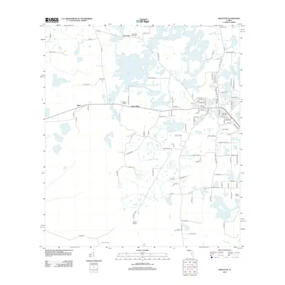
2012 Map of Mascotte
USGS Topo · Published 2012About this map
Slones Ridge rises above the low-lying wetlands of Lake County, Florida, defining a landscape of agricultural roads and scattered homesteads. The central and eastern portions of the map are defined by a complex network of freshwater basins, including Lake Jackson, Gallows Lake, and Big Prairie. This 2012 survey illustrates the transition from rural acreage to more dense residential development around the Mascotte Water Tower and local Po. The presence of numerous burial sites, such as the Tuscannoga Baptist Cem, Mascotte Cem, and the Fender Family Cem, provides significant value for genealogical research. Aviation history is noted at the Osborn Airfield, while the interior remains sparsely populated with outposts like East Tower Camp and the settlement of Tuscannoga.
Find a feature on this map
110 named features on this map. Tap any name to fly to it.
Don’t see what you’re looking for? This feature index may not catch every label — zoom into the map to look around manually.
Map Details
Editions of this 2012 Mascotte Map
This is the sole edition of this map. No revisions or reprints were ever made.
Other maps of this area

1955 · Plant City
USGS Topo · 1:250,000

1955 · Orlando
USGS Topo · 1:250,000

1957 · Orlando
USGS Topo · 1:250,000

1958 · Orlando
USGS Topo · 1:250,000

1958 · Plant City
USGS Topo · 1:250,000

1958 · Webster
USGS Topo · 1:24,000

1958 · Bushnell
USGS Topo · 1:24,000

1959 · Plant City
USGS Topo · 1:250,000

1959 · Lake Nellie
USGS Topo · 1:24,000
1960 · Bay Lake
USGS Topo · 1:24,000