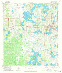
1969 Map of Mascotte
USGS Topo · Published 1971About this map
Mascotte and Groveland anchor the eastern edge of this landscape during the late 1960s, a region defined by an intricate network of wetlands and citrus-friendly ridges. The Seaboard Coast Line railroad cuts across the terrain, passing through the settlement of Mabel and skirting Sloans Ridge. This era shows a transition in land use, with several quarries and a claypit indicating local extraction industries alongside the conservation boundaries of the Withlacoochee State Forest.
Find a feature on this map
32 named features on this map. Tap any name to fly to it.
Don’t see what you’re looking for? This feature index may not catch every label — zoom into the map to look around manually.
Map Details
Editions of this 1969 Mascotte Map
This is the sole edition of this map. No revisions or reprints were ever made.
Other maps of this area

1955 · Plant City
USGS Topo · 1:250,000

1955 · Orlando
USGS Topo · 1:250,000

1957 · Orlando
USGS Topo · 1:250,000

1958 · Orlando
USGS Topo · 1:250,000

1958 · Plant City
USGS Topo · 1:250,000

1958 · Webster
USGS Topo · 1:24,000

1958 · Bushnell
USGS Topo · 1:24,000

1959 · Plant City
USGS Topo · 1:250,000

1959 · Lake Nellie
USGS Topo · 1:24,000
1960 · Bay Lake
USGS Topo · 1:24,000