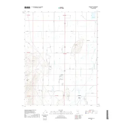
2018 Map of Mason Butte
USGS Topo · Published 2018About this map
The Walker River meanders through the fertile agricultural expanse of Mason Valley, defining the region's character in this 2018 survey. The landscape is a study in Western water management, characterized by an intricate network of irrigation channels including the Wabuska Drain, Spragg-Alcorn-Bewley Ditch, and Nichols-Merritt Ditch. These waterways support the valley's settlement patterns, which are framed by the prominent Mason Butte at the valley floor and the rising slopes of the Singatse Range and Carson Hill to the west. Near the southern edge, the Yerington Municipal Airport serves as a modern waypoint, while to the north, the Fort Churchill Cooling Ponds mark a significant industrial landmark. This map captures the intersection of desert topography and human engineering, from the high vantage point of Mason Pass down to the distributed rural homesteads along Rosaschi Rd and Peeples Ln.
Find a feature on this map
54 named features on this map. Tap any name to fly to it.
Don’t see what you’re looking for? This feature index may not catch every label — zoom into the map to look around manually.
Map Details
Editions of this 2018 Mason Butte Map
This is the sole edition of this map. No revisions or reprints were ever made.
Other maps of this area

1891 · Wabuska
USGS Topo · 1:125,000

1891 · Wellington
USGS Topo · 1:125,000

1893 · Wellington
USGS Topo · 1:125,000

1894 · Wabuska
USGS Topo · 1:125,000

1948 · Walker Lake
USGS Topo · 1:250,000

1957 · Walker Lake
USGS Topo · 1:250,000

1957 · Wellington
USGS Topo · 1:62,500

1957 · Como
USGS Topo · 1:62,500

1957 · Wabuska
USGS Topo · 1:62,500

1957 · Yerington
USGS Topo · 1:62,500