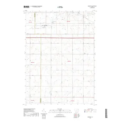
2018 Map of Masonville
USGS Topo · Published 2018About this map
Masonville serves as the primary settlement hub on this part of the Buchanan and Delaware County line. The landscape is defined by the headwaters and meandering courses of several local waterways, including Prairie Creek which flows near the town and Silver Creek winding through the southwestern sections. Remnants of early transportation routes are visible in the path of Early Stagecoach Rd in the northeastern corner, providing a link to the nineteenth-century movement of people and mail across the Iowa prairie. Several burial grounds, such as Greenwood Cemetery, Saint Mary Cemetery, and Sand Creek Cemetery, are distributed throughout the townships, offering critical points of interest for genealogists tracing family histories in these rural agricultural districts. The rectilinear road grid, marked by numbered streets from 200th St to 285th St, illustrates the enduring influence of the Public Land Survey System on the modern Iowa landscape.
Find a feature on this map
40 named features on this map. Tap any name to fly to it.
Don’t see what you’re looking for? This feature index may not catch every label — zoom into the map to look around manually.
Map Details
Editions of this 2018 Masonville Map
This is the sole edition of this map. No revisions or reprints were ever made.
Other maps of this area

1900 · Anamosa
USGS Topo · 1:125,000

1901 · Oelwein
USGS Topo · 1:125,000

1902 · Elkader
USGS Topo · 1:125,000

1903 · Winthrop
USGS Topo · 1:125,000

1959 · Dubuque
USGS Topo · 1:250,000

1961 · Dubuque
USGS Topo · 1:250,000

1962 · Dubuque
USGS Topo · 1:250,000

1965 · Thorpe
USGS Topo · 1:24,000

1965 · Lamont
USGS Topo · 1:24,000

1965 · Dundee
USGS Topo · 1:24,000