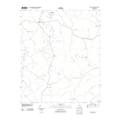
2011 Map of Massey Hill
USGS Topo · Published 2011About this map
Massey Hill and the surrounding Wilkinson County countryside are defined by a complex network of waterways and extensive kaolin mining infrastructure in this early 21st-century landscape. The area is heavily intersected by creeks, including Clear Creek, Big Sandy Creek, and Alligator Creek, which create a fragmented terrain of wetlands and ridges. Industrial activity is prominently marked by the Freeport Kaolin Tailings Pond Dam in the north, signaling the importance of the clay industry to the local economy.
Find a feature on this map
44 named features on this map. Tap any name to fly to it.
Don’t see what you’re looking for? This feature index may not catch every label — zoom into the map to look around manually.
Map Details
Editions of this 2011 Massey Hill Map
This is the sole edition of this map. No revisions or reprints were ever made.
Other maps of this area

1916 · Irwinton
USGS Topo · 1:62,500

1920 · Irwinton
USGS Topo · 1:62,500

1956 · Gordon
USGS Topo · 1:62,500

1956 · Jeffersonville
USGS Topo · 1:62,500

1957 · Macon
USGS Topo · 1:250,000

1958 · Macon
USGS Topo · 1:250,000

1964 · Macon
USGS Topo · 1:250,000
1973 · Gordon
USGS Topo · 1:24,000

1973 · Massey Hill
USGS Topo · 1:24,000
1973 · Napier Pond
USGS Topo · 1:24,000